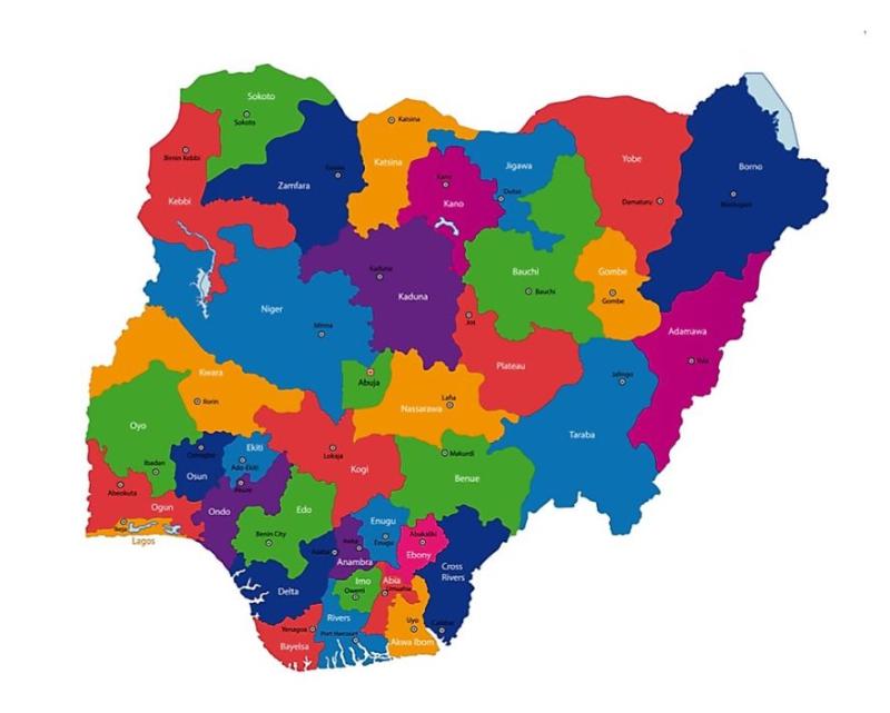
Thirty-six states and one federal capital territory make up the nation known as Nigeria. According to the Constitution of the Federal Republic of Nigeria, each country’s 36 states is a political entity with some independence from the central government. The 36 states are equal but subordinate to the federal government, which holds ultimate sovereignty. Nigeria’s federal capital, Abuja, is found in the Federal Capital Territory (FCT). Although it is not a state, the Federal Capital Territory (FCT) is governed by elected representatives who report to the federal government. Local government areas (LGAs) are smaller sections of each state. Nigeria has 774 different local governments. Changes to the constitution proposed by the National Assembly require approval from 36 of the Federation’s 54 states, or two-thirds of the total.
Abia State
Abia State is in Nigeria’s Southeast geopolitical zone. It borders Enugu and Ebonyi to the north and northeast, Imo to the west, Cross River to the east, Akwa Ibom to the southeast, and Rivers to the south. Aba, Bende, Isuikwuato, and Afikpo are its four most populous regions (but Afikpo was later joined with a part of Enugu state to create Ebonyi state in 1996). Aba is the state’s major metropolis and commercial hub. Abia ranks 32nd in size and 27th in population, with about 3,720,000 people in 2016. Geographically, the state is split between the Niger Delta swamp woods in the south and the Cross–Niger transition forests and savanna in the north. Imo and Aba Rivers flow along Abia’s western and southern boundaries. Abia State is home to several ethnic groups, but the Igbo are the majority. Abia State was part of the Arochukwu-based Aro Confederacy till British troops conquered it in the early 1900s. After the war, the British incorporated the territory into the Southern Nigeria Protectorate, which ultimately merged into British Nigeria. After the merger, Abia became a centre of anti-colonial resistance with the Women’s War in Oloko. Abia was part of the post-independence Eastern Region until 1967 when it became part of East Central State. Less than two months later, the former Eastern Region tried secession in the 3-year Nigerian Civil War, with Abia as part of Biafra. After the war, the East Central State was merged until 1976, when Murtala Muhammed founded Imo State (containing now-Abia). In 1995, a portion of Abia’s northeast was removed to form the new Ebonyi State. Abia State’s economy is centred on oil, gas, and agriculture, notably yams, maise, taro, oil palm, and cassava. Manufacturing is essential in Aba. Due to its expanding population and industrialisation, Abia has the country’s eighth-highest Human Development Index.
Local Government Areas in Abia State
- Arochukwu
- Ini
- Obi Ngwa
- Umuahia South
- Umuahia North
- Ikwuano
- Isiukwato
- Ukwa West
- Aba South
- Aba North
- Isiala Ngwa North
- Isiala Ngwa South
- Obingwa
- Umunneochi
- Ugwunagbo
- Ukwa East
Adamawa State
Adamawa state is in Nigeria’s North-East geopolitical zone, flanked by Borno, Gombe, and Taraba. Its eastern boundary is with Cameroon. Adamawa state draws its name from the mediaeval emirate of Adamawa, with Yola as its capital. Nigeria’s most diverse state. Former Gongola state was split into Adamawa and Taraba in 1991, creating approximately 100 indigenous ethnic groups. Since General Ibrahim Badamsi Babangida’s military dictatorship carved Adamawa State out of the former Gongola State in 1991, 10 military and civilian men have controlled the state’s levers of power and played significant roles in reshaping it. Adamawa state is the eighth largest but the thirteenth least populous with 4.25 million people in 2016. Geographically, the state consists of mountain ranges (Atlantika, Mandara, and Shebshi) and the Adamawa Plateau, crossed by valleys and rivers, notably the Benue and Gongola rivers. Adamawa’s lowlands are part of the West Sudanian savanna in the north and the Guinean forest-savanna mosaic in the south. Elevated sections are part of the Mandara Plateau mosaic and Cameroonian Highlands forests ecoregions. In the extreme south of the state is Gashaka Gumti National Park, a large wildlife park with bushbuck, African buffalo, patas monkey, black-and-white colobus, giant pangolin, and hippopotamus, as well as some of Nigeria’s last remaining Nigeria-Cameroon chimpanzee, African leopard, and African golden cat populations. Adamawa state has been inhabited by various ethnic groups, including the Bwatiye (Bachama), Bali, Bata (Gbwata), Gudu, Mbula-Bwazza, and Nungurab (Lunguda) in the central region; the Kamwe in the north and central part; the Jibu in the far south; the Kilba, Marghi, Waga, and Wula in the north; and the Mumuye in the south. 55% of Adamawa’s population is Sunni Muslim, 30% is Christian (primarily Lutheran, EYN, ECWA, and Pentecostal), and 15% is ethnic. The Fulani jihad took some modern-day Adamawa state and founded the Adamawa Emirate under the Sokoto Caliphate. In the Adamawa Wars, 90 years later, Germany and Britain destroyed the emirate and partitioned the area. The British-controlled area (most of modern-day Adamawa) became part of the Northern Nigeria Protectorate, which amalgamated with British Nigeria before becoming Nigeria in 1960. The German-controlled area was part of German Kamerun until WWI’s Kamerun campaign. After the war, eastern Adamawa became most of Northern Cameroons inside British Cameroons until 1961, when a referendum led to its union with Nigeria. Adamawa State was part of the post-independence Northern Region until 1967, when it became part of the North-Eastern State. Gongola State was founded in 1976 after the Northeastern state was separated. Gongola was divided into Taraba and Adamawa 15 years after statehood. Adamawa State relies on cattle and crops like cotton, groundnuts, millet, cassava, guinea corn, and yams. Adamawa has the 11th lowest Human Growth Index in the country after years of Boko Haram insurgency; however, development has resumed since 2016.
Local Government Areas in Adamawa State
- Demsa
- Fufore
- Ganye
- Girei
- Gombi
- Guyuk
- Hong
- Jada
- Lamurde
- Madagali
- Maiha
- Mayo-Belwa
- Michika
- Mubi North
- Mubi South
- Numan
- Shelleng
- Song
- Toungo
- Yola North
- Yola South
Akwa Ibom State
Akwa Ibom State is a state in the South-South geopolitical zone of Nigeria, bordered on the east by Cross River State, on the west by Rivers State and Abia State, and the south by the Atlantic Ocean. The state takes its name from the Qua Iboe River, which bisects the state before flowing into the Bight of Bonny. Akwa Ibom split from Cross River State in 1987, with its capital Uyo and 31 local government areas. Of the 36 states, Akwa Ibom is the 30th largest in the area and the fifteenth-most populous, with an estimated population of nearly 5.5 million as of 2016. Geographically, the state is divided between the Central African mangroves in the coastal far south and the Cross–Niger transition forests in the rest of the state. Other important geographical features are the Imo and Cross rivers, which flow along Akwa Ibom’s eastern and western borders. At the same time, the Kwa Ibo River bisects the state before flowing into the Bight of Bonny. In the state’s southeast corner is the Stubb’s Creek Forest Reserve, a heavily threatened wildlife reserve that contains declining crocodile, putty-nosed monkey, red-capped mangabey, and Sclater’s guenon populations along with potentially extirpated populations of African leopard and Nigeria-Cameroon chimpanzee. Offshore, the state is also biodiverse as there are large fish populations along with various cetacean species including bottlenose dolphins, pantropical spotted dolphins, humpback whales, and killer whales. Different ethnic groups have inhabited modern-day Akwa Ibom State for hundreds of years, primarily the closely related Ibibio, Anaang, and Obolo – Oron peoples in the North-East, North-West, and Southern zones of the state, respectively. In the pre-colonial period, Akwa Ibom State was divided into various city-states like the Ibom Kingdom and Akwa Akpa before the latter became a British protectorate in 1884 as a part of the Oil Rivers Protectorate. In the early 1900s, the British gained formal control of the area before incorporating the protectorate (now renamed the Niger Coast Protectorate) into the Southern Nigeria Protectorate, which later merged into British Nigeria; after the merger, much of modern-day Akwa Ibom became a centre of anti-colonial resistance during the Women’s War and political activism through the Ibibio State Union. After independence in 1960, the area of now-Akwa Ibom was a part of the post-independence Eastern Region until 1967, when the region was split, and the area became part of the South-Eastern State. Less than two months afterwards, the Igbo-majority former Eastern Region attempted to secede as the state of Biafra; in the three-year-long Nigerian Civil War, now-Akwa Ibom was hard-fought over in the prelude to the Invasion of Port Harcourt while Biafran forces persecuted people from Akwa Ibom as they were mainly non-Igbo. At the war’s end and the reunification of Nigeria, the South-Eastern State was reformed in 1976 when it was renamed Cross River State. Eleven years later, Cross River State was divided, with western Cross River being broken off to form the new Akwa Ibom State. Economically, Akwa Ibom State is based around the production of crude oil and natural gas as the highest oil-producing state in the country, with Ibeno, Mbo and Eastern Obolo as oil-producing LGAs. Key minor industries involve agriculture as the state has substantial cocoyam, yam, and plantain crops along with fishing and heliciculture. Despite its vast oil revenues, Akwa Ibom has the seventeenth-highest Human Development Index in the country in large part due to years of systemic corruption.
Local Government Areas in Akwa Ibom State
- Abak
- Eastern Obolo
- Eket
- Esit-Eket
- Essien Udim
- Etim-Ekpo
- Etinan
- Ibeno
- Ibesikpo-Asutan
- Ibiono-Ibom
- Ika
- Ikono
- Ikot Abasi
- Ikot Ekpene
- Ini
- Itu
- Mbo
- Mkpat-Enin
- Nsit-Atai
- Nsit-Ibom
- Nsit-Ubium
- Obot-Akara
- Okobo
- Onna
- Oron
- Oruk Anam
- Ukanafun
- Udung-Uko
- Uruan
- Urue-Offong/Oruko
- Uyo
Anambra State
Anambra State is in southeast Nigeria. The state was formed on August 27 1991. Delta, Imo, Enugu, and Kogi border Anambra. Over 9 million people live in the state, according to the 2022 census. East Central State became Oklahoma in 1976. The state is named after the Omambala River. Omambala is known by its Anglicized name, Anambra. Between 2006 and 2020, Awka’s population grew from 700,000 to over 6 million. Onitsha, a pre-colonial port city, is an important commercial hub. Anambra State, nicknamed “Light of the Nation,” is the eighth-most populated state. Onitsha, the state’s largest and most populous metropolitan region, has about 8.5 million people, making it the second-largest urban area in Nigeria and third in Africa. With around 8 million people, Onitsha is the 47th largest metropolitan area in the world. Anambra, the second-smallest state, is relatively populous. Since the 9th century AD, Anambra State has been home to several civilisations, notably the ancient Kingdom of Nri, whose capital was Igbo-Ukwu. Igbo is the lingua franca for Anambra State’s residents. Anambra State joined the breakaway Republic of Biafra during the Nigerian Civil War (1967–1970). During the war, Anambra State was devastated by starvation. Anambra State is highly urbanised and has reduced poverty significantly.
Local Government Areas in Anambra State
- Aguata
- Awka North
- Awka South
- Anambra East
- Anambra West
- Anaocha
- Ayamelum
- Dunukofia
- Ekwusigo
- Idemili North
- Idemili South
- Ihiala
- Njikoka
- Nnewi North
- Nnewi South
- Ogbaru
- Onitsha North
- Onitsha South
- Orumba North
- Orumba South
- Oyi
Bauchi State
Bauchi State is in Nigeria’s North-East geopolitical zone, bordered by Kano, Jigawa, Taraba, Plateau, Gombe, Yobe, and Kaduna. It’s named after the capital city, Bauchi. The state was created in 1976 from North-Eastern State. In 1996, Gombe State became a separate state. Bauchi is the fifth-largest state in area and seventh-most populous, with about 6,530,000 people in 2016. Geographically, the state is divided between the West Sudanian and Sahelian savannas, with a minor area of the Jos Plateau in the southwest. Yankari National Park in southern Bauchi State features huge populations of waterbuck, African buffalo, patas monkey, hippopotamus, roan antelope, western hartebeest, and some of Nigeria’s last remaining West African lion, African leopard, and African bush elephant populations. Bauchi State has been populated by Bolewa, Butawa, and Warji in the central region; Fulani, Kanuri, and Karai-Karai in the north; Fulani and Gerawa in and around Bauchi; Zaar (Sayawa) in the south; Tangale in the southeast; and Jarawa in the southwest. Religiously, 85% of the state’s population is Muslim, with smaller Christian and conservative minorities. The Fulani jihad founded the Bauchi Emirate under the Sokoto Caliphate in the early 1800s. Ninety years later, a British expedition captured the emirate and integrated Bauchi Province into the Northern Nigeria Protectorate, which ultimately amalgamated into British Nigeria before becoming Nigeria in 1960. Bauchi State was part of the post-independence Northern Region until 1967, when it became part of the North-Eastern State. Bauchi State was founded in 1976 after the North-Eastern State was separated. Twenty years after statehood, western LGAs became Gombe State. Bauchi State’s economy depends on cattle and crops like cotton, groundnuts, millet, tomatoes, and yams. Since statehood, modern irrigation facilities have increased agricultural productivity. Other enterprises include food manufacturing and canning, tin and columbite mining, and Yankari National Park’s Wikki Warm Springs.
Local Government Areas in Bauchi State
- Bauchi
- Tafawa Balewa
- Dass
- Toro
- Bogoro
- Ningi
- Warji
- Ganjuwa
- Kirfi
- Alkaleri
- Darazo
- Misau
- Giade
- Shira
- Jamaare
- Katagum
- Itas/Gadau
- Zaki
- Gamawa
- Damban
Bayelsa State
Bayelsa is a Nigerian state in the Niger Delta. Bayelsa State was founded from Rivers State in 1996, making it one of the newest states. Yenagoa, the capital of Bayelsa State, is prone to annual flooding. It borders Rivers State to the east, Delta State to the west, and the Atlantic Ocean to the south. It’s 10,773 km2. State has 8 LGAs: Ekeremor, Kolokuma/Opokuma, Yenagoa, Nembe, Ogbia, Sagbama, Brass, and Southern Ijaw. Formerly part of Rivers State, it borders Delta State. Bayelsa State’s ancestral towns speak Ijaw, Isoko, and Urhobo. It’s also the Urhobo’s traditional home in Sagbama. The 2006 census ranked the state as Nigeria’s smallest by population and area. Bayelsa State features a riverine and estuarine landscape, prohibiting the development of extensive road infrastructure. Bayelsa State’s economy is dominated by oil as part of the oil-rich Niger Delta. The state is home to Nigeria’s first oilfield, Oloibiri, and produces 30-40% of the country’s oil. The “Glory of all Lands” state contains 18 trillion cubic feet of gas. Despite having one of the country’s most significant crude oil and natural gas resources, the state is afflicted by poverty and oil spill pollution.
Local Government Areas in Bayelsa State
- Brass
- Ekeremor
- Kolokuma/Opokuma
- Nembe
- Ogbia
- Sagbama
- Southern Ijaw
- Yenagoa
Benue State
Benue State has a population of 4,253,641 (2006 census). The state was one of 7 formed in 1976. The Benue River, Nigeria’s second largest, gives the state its name. The state borders Nasarawa, Taraba, Kogi, Enugu, Ebonyi, Cross-Rivers, and Cameroon. Tiv, Idoma, and Igede predominate. Benue’s minorities include Etulo, Igbo, and Jukun. The capital is Makurdi. Oranges, mangoes, sweet potatoes, cassava, soya bean, guinea corn, flax, yams, sesame, rice, groundnuts, and Palm trees are produced in Benue. Benue State was created out of northern Nigeria’s protectorate at the turn of the century. The territory was called Munshi Province until 1918 when the Benue River became its namesake. Benue State was founded from Benue-Plateau State, Igala, and part of Kwara State in 1976. In 1991, parts of Benue and Kwara states (mainly Igala-speaking areas) became Kogi State. Igbo live in Obi, Oju, and other LGAs. It’s the “Heartbeat of the Middle Belt” north of the Niger River. Otukpo is renowned as the Lion’s Heart and the Land of the Brave.
Local Government Areas in Benue State
- Ado
- Agatu
- Apa
- Buruku
- Gboko
- Guma
- Gwer East
- Gwer West
- Katsina-Ala
- Konshisha
- Kwande
- Logo
- Makurdi
- Obi
- Ogbadibo
- Ohimini
- Oju
- Okpokwu
- Otukpo
- Tarka
- Ukum
- Ushongo
- Vandeikya
Borno State
Borno State is in Nigeria’s North-East geopolitical zone, bordered by Yobe to the west, Gombe to the southwest, and Adamawa to the south. Its eastern border forms part of the national border with Cameroon, its northern border forms part of the national border with Niger, and its northeastern border forms the entire national border with Chad, making it the only Nigerian state to border three foreign countries. Borno State draws its name from the former emirate of Borno, with Maiduguri as its capital. The state was founded in 1976 from North-Eastern State. In 1991, Yobe State became a separate state. Borno is the second-largest state after Niger. Despite its size, the state’s population was 5.86 million in 2016. Geographically, the state is divided between the semi-desert Sahelian savanna in the north and the West Sudanian savanna in the centre and south. In the state’s extreme northeast is Lake Chad and its flooded savanna ecoregion, fed by the Yobe River, which marks the state’s border with Niger until it reaches the lakebed. Chad Basin National Park, in the state’s centre, is home to black crowned cranes, spotted hyenas, patas monkeys, roan antelopes, and Nigeria’s last African bush elephants. Sambisa Forest was taken over by Boko Haram in the early 2010s, forcing many animals to escape. Large animals were seen again in 2019 and 2020 when a herd of migratory elephants returned to Borno. Borno State has been inhabited by various ethnic groups for years, including the Dghwede, Glavda, Guduf, Laamang, Mafa, and Mandara in the central region; the Afade, Yedina (Buduma), and Kanembu in the extreme northeast; the Waja in the extreme south; and the Kyibaku, Kamwe, Kilba, Margi groups and Babur in the south. Kanuri and Shuwa Arabs live 85% of the state’s population is Muslim, with smaller Christian and traditionalist populations (particularly in the south). Borno State was part of the Kanem Empire, which stretched from modern-day southern Libya (Fezzan) to modern-day Chad. After fruitless warfare in the late 1300s, the Kanem Empire became the Bornu Empire and ruled the region for 500 years. Bornu fell after the Fulani jihad undermined it in the early 1800s. Southern Borno State was absorbed into the Adamawa Emirate under the Sokoto Caliphate. Rabih az-Zubayr, a Sudanese warlord, seized the Empire 80 years later and ruled until the 1900 Battle of Kousséri. The Adamawa Emirate lost the Adamawa Wars against Germany and Britain. Rabih’s holdings (later the Borno Emirate) and the Adamawa Emirate were partitioned among colonial powers, with the modern-day Borno State split between Germany and the British Empire. The British-controlled territory was absorbed into British Nigeria before becoming Nigeria in 1960. The German-controlled area (modern-day border with Cameroon) formed Deutsch-Bornu as part of German Kamerun until the Kamerun campaign of World War I. After the war, what is now Borno State’s eastern periphery remained part of Northern Cameroons under British Cameroons until 1961, when a referendum led to a unification with Nigeria. Borno State was part of the post-independence Northern Region until 1967, when it became part of the North-Eastern State. Borno State was founded in 1976 after North-Eastern State was separated. Fifteen years after statehood, LGAs in the west became Yobe State. In the early 2000s, the state became the epicentre of Boko Haram’s 2009 insurgency. From 2012 to 2015, the insurgency increased drastically, with much of the state falling under the group’s control. In 2015, it became the world’s deadliest terror group and displaced millions. Following a 2015 mass multinational offensive and infighting within the terrorists, Boko Haram was forced from its strongholds into the Sambisa Forest and some islands in Lake Chad by 2017; however, terrorists continue to be a threat statewide with frequent attacks on civilian and military targets. Before the Boko Haram war, Borno State’s rural economy relied mainly on livestock and agriculture, while Maiduguri was a significant regional trading and service centre. After years of insurgency impeding development and displacing farmers from rural regions, Borno has the country’s 13th-lowest Human Progress Index. However, development has been revived since 2016.
Local Government Areas in Borno State
- Askira-Uba
- Bama
- Biu
- Chibok
- Damboa
- Dikwa
- Gwoza
- Hawul
- Jilbe town
- Kaga
- Kala/Balge
- Konduga
- Kukawa
- Kwaya-Kusar
- Maiduguri
- Monguno
- Ngala
Cross River State
Cross River State is located in south-south Nigeria. The state, named for the Cross River, was created on May 27, 1967. Its capital is Calabar, it borders Benue, Ebonyi, Abia, and Akwa Ibom states, and its eastern boundary is with Cameroon. Cross River state, formerly known as South-Eastern State, encompassed Akwa Ibom state before 1987. Cross River is the 19th largest state in Nigeria and the 27th most populous, with approximately 3.8 million people in 2016. Geographically, the state is divided between the Guinean forest-savanna mosaic in the north and Cross–Sanaga–Bioko coastal forests in the interior. The minor ecoregions are the Central African mangroves and the Cameroonian Highlands forests. The Cross River bisects the state’s interior before forming much of its western boundary and draining into the Cross River Estuary. The Calabar and Great Kwa rivers run from the Oban Hills before surrounding Calabar and entering the Cross River Estuary. Cross River National Park, Afi Mountain Wildlife Sanctuary, and Mbe Mountains Community Forest lie in the state’s forested interior. These wildlife reserves feature Preuss’s red colobus, African forest buffalo, bat hawk, tree pangolin, grey-necked rockfowl, and West African slender-snouted crocodile; Nigeria-Cameroon chimpanzee, drill, African forest elephant, and Cross River gorilla populations. Cross River state has been home to several ethnic groups for hundreds of years, including the Efik of the riverside south and Calabar, the Ekoi (Ejagham) of the inland south, the Akunakuna, Boki, Bahumono, and Yakö (Yakurr) of the central region, and the Bekwarra, Bette, Igede, Ukelle (Kukele) of the north. Pre-colonial Cross River was divided between ethnic groups, some joining the Aro Confederacy and the Efik founding Akwa Akpa (Old Calabar). In 1884, it became the capital of the Oil Rivers Protectorate, but the British didn’t establish legal control of the territory until the early 1900s. The protectorate (now called the Niger Coast Protectorate) was later integrated into British Nigeria. After the merger, Cross River became a hotbed of anti-colonial resistance during the Women’s War and trade through Calabar. Cross River state was part of the post-independence Eastern Region until 1967, when it became part of the South-Eastern state. Less than two months later, the Igbo-majority of the former Eastern Region tried to secede as Biafra in the three-year Nigerian Civil War. Operation Tiger Claw was fought over Calabar and its port, while Biafran soldiers persecuted Cross River state’s non-Igbos. After the war and Nigeria’s reunification, the South-Eastern state was reconstituted and renamed Cross River. Eleven years later, western Cross River became Akwa Ibom. The Greentree Agreement gave the oil-producing Bakassi Peninsula to Cameroon. Cross River’s economy depends on cocoyam, rubber, oil palm, yam, cocoa, cashews, plantain crops, and fishing. Tourism in nature reserves, Ikom Monoliths, Calabar Carnival, and Obudu Mountain Resort are key small industries. Cross River state has the 13th-highest HDI and many tertiary institutions.
Local Government Areas in Cross River State
- Abi
- Akamkpa
- Akpabuyo
- Bekwarra
- Bakassi
- Biase
- Boki
- Calabar Municipal
- Calabar South
- Etung
- Ikom
- Obanliku
- Obubra
- Obudu
- Odukpani
- Ogoja
- Yakuur
- Yala
Delta State
Delta State is in Nigeria’s South-South zone. The state was founded from the former Bendel State on August 27, 1991. The state is bordered on the north by Edo, the east by Anambra and Rivers, and on the south by Bayelsa. To the west is the 160-kilometre Bight of Benin. In 1991, the state had 12 local government areas; it presently has 25. Asaba, the state capital, sits near the River Niger in the northeast, while Warri and Uvwie are the economic hubs. Delta is the 23rd largest state in size and the 12th most populous, with approximately 5.6 million residents in 2016. Geographically, the state is divided between Central African mangroves in the southwest and Nigerian lowland forests in the rest, with a minor piece of Niger Delta swamp forests in the far south. The River Niger and its distributary, the Forçados River, flow along Delta’s eastern and southern borders. The Escravos River runs through Warri, and dozens of smaller Niger distributaries make up much of the western Niger Delta. The state’s nature contains vulnerable dwarf crocodile, Grey parrot, African fish eagle, mona monkey, and African manatee species, as well as potentially extinct African leopard and Nigeria-Cameroon chimpanzee populations. Offshore, there are Lesser African threadfin, crabs, blue mussels, and cetacean species. What is now Delta State is made up of seven distinct ethnic groups, including the Urhobos in the delta central senatorial district; Ukwuani, Ika, and Aniocha-Oshimili (Igbo) in the Delta north senatorial district; the Isokos, Ijaws, and the Itsekiris in the Delta south senatorial district; and other minor tribes such as the Olukumi, Igalas in the Delta north region, who have Delta State was divided into monarchies like Warri and Agbor before becoming part of the British Oil Rivers Protectorate in 1884. In the early 1900s, the British merged the protectorate (now called the Niger Coast Protectorate) into British Nigeria. The Ekumeku Movement prevented colonial soldiers from permanently controlling the modern-day Delta State until the 1910s. Delta had one of the few parts of now-Nigeria under French authority, as the UK leased Forcados to France from 1903 until 1930. Delta was part of the post-independence Western Region until 1963 when it became part of the Mid-Western Region. In 1967, the Igbo-majority of the former Eastern Region attempted to secede as the state of Biafra and invaded the Mid-Western Region to capture Lagos and end the war quickly; Biafran forces were halted and eventually pushed back but briefly declared the captured Mid-Western Region (including Delta State) the Republic of Benin. Biafran forces and non-Igbo Delta State residents were at odds during the occupation. Nigerian army massacred Igbos in Asaba after liberating the Mid-West. After the war and Nigeria’s reunification, the Mid-Western Region was reorganised and renamed Bendel State. In 1991, Bendel State separated into Edo and Delta. Delta State is the country’s top crude oil and natural gas producer. Minor industries include oil palm, yam, cassava, fishing, and heliciculture. Delta has the country’s fourth-highest Human Development Index due to its massive oil profits. However, disputes between oil firms and local communities and years of systemic corruption have led to hostilities that are often connected to the lack of development in host communities.
Local Government Areas in Delta State
- Aniocha North
- Aniocha South
- Burutu
- Bomadi
- Ethiope East
- Ethiope West
- Ika North East
- Ika South
- Isoko North
- Isoko South
- Ndokwa East
- Ndokwa West
- Oshimili North
- Oshimili South
- Okpe
- Patani
- Sapele
- Udu
- Ughelli North
- Ughelli South
- Ukwuani
- Uvwie
- Warri North
- Warri South
- Warri South West
Ebonyi State
Ebonyi State is in Nigeria’s Southeast geopolitical zone, bordered by Benue to the north and northeast, Enugu to the west, Cross River to the east and southeast, and Abia to the southwest. Ebonyi State was created from Abia and Enugu in 1996 and has Abakaliki as its capital. Ebonyi is one of Nigeria’s smallest states, ranking 33rd in area and 29th in population as of 2016. Geographically, the state is split between Cross–Niger transition forests in the south and a Guinean forest-savanna mosaic in the north. Cross River and its tributary, the River Aloma, flow along Ebonyi’s south-eastern and eastern borders, respectively. Abonyi (Aboine), Asu, and Eze Aku rivers flow through the state’s interior. After independence in 1960, Ebonyi was part of the Eastern Region until 1967, when it became part of the East Central State. Less than two months later, the former Eastern Region tried independence in the three-year Nigerian Civil War, with Ebonyi as part of Biafra. After the war and Nigeria’s reunification, the East Central State was reconstituted in 1976, when its north became Anambra and its south became Imo. Anambra and Imo were split into Enugu and Abia 15 years later. In 1996, Enugu’s east and Abia’s northeast formed Ebonyi State. Ebonyi State’s economy relies on yams, rice, oil palm, and cassava. Lead, zinc, limestone deposits around Abakaliki and hand-woven baskets at Ntezi are important minor industries. Ebonyi has a high Human Development Index and many tertiary institutions.
Local Government Areas in Ebonyi State
- Abakaliki
- Afikpo
- Afikpo South
- Ebonyi
- Ezza North
- Ezza South
- Ikwo
- Ishielu
- Ivo
- Izzi
- Ohaukwu
- Ohaozara
- Onicha
Edo State
Edo State is in Nigeria’s South-South geopolitical zone. As of the 2006 National population census, the state was ranked as the 24th most populated state (3,233,366) in Nigeria. However, there was controversy over the population census figures; for example, this state was ranked 24 population-wise in 2006 and was number 16 in terms of voter registration in the country in 2019. This shows that the census conducted in 2006 is not a testament to reality on the ground. The state’s population will reach 8,000,000 in 2022. Edo is Nigeria’s 22nd-largest state. Benin Metropolis, the state’s capital and largest city, is Nigeria’s rubber manufacturing hub. Formerly Bendel State, it’s known as the nation’s heartbeat. Edo State borders Kogi, Anambra, Delta, and Ondo states. Edo State’s contemporary borders include former Benin Empire areas. Edo, now Benin City, had some of the world’s most incredible earthworks. In 1897, the British Empire destroyed most of Edo and incorporated the province into the Southern Nigeria Protectorate. Edo State is home to the Edo (or Bini), Esan, Owan, and Afemai peoples. Benin City is home to many Edo speakers. Edo State practises Christianity. Portuguese missionaries introduced it in the 15th century. Islam and indigenous religions are also practised.
Local Government Areas in Edo State
- Akoko-Edo
- Egor
- Esan Central
- Esan North-East
- Esan South-East
- Esan West
- Etsako Central
- Etsako East
- Etsako West
- Igueben
- Ikpoba-Okha
- Oredo
- Orhionmwon
- Ovia North-East
- Ovia South-West
- Owan East
- Owan West
- Uhunmwonde
Ekiti State
Ekiti State is in southwestern Nigeria, bordered by Kwara, Kogi, Ondo, and Osun states. Ekiti State was created from Ondo State in 1996 and features Ado-Ekiti as its capital. It’s named for the Ekiti people, a Yoruba subgroup that makes up most of the state’s population. Ekiti, one of Nigeria’s smallest states, ranks 31st in area and 30th in population, with about 3.3 million people in 2016. Geographically, the state is divided between Nigerian lowland forests and Guinean forest-savanna mosaics. The Ise Forest Reserve is home to one of the last remaining Nigeria-Cameroon chimpanzee groups, with roughly 20 chimps. Ekiti State adopted a state tree as a symbol in March 2022. Obeche (Triplochiton scleroxylon) was chosen as State Tree on World Forest Day 2022 because of its local popularity and environmental, economic, and cultural value. Ekiti people, a Yoruba subgroup, have dominated modern-day Ekiti State for millennia alongside Akoko Yoruba minorities. 85% of the state’s population is Christian, with 10% Muslim and 5% traditionalist. In pre-colonial times, the territory that is now Ekiti State was dominated by the Oyo Empire, Benin Empire, and the Ekiti states, which constituted the Ekiti Confederacy. From 1877 to 1893, Fabunmi Okemesi led the Confederacy in the Kiriji War against the Ibadan Kingdom and other Western Yoruba groups. The war ended in a British-brokered stalemate before the area was colonised and incorporated into the British Southern Nigeria Protectorate, which later merged into British Nigeria in 1914. Ekiti was part of the post-independence Western Region until 1967 when it became part of the Western State. Western State’s east became Ondo State in 1976. Twenty years later, Ondo’s northwest (called the Ekiti Zone) became Ekiti State. Ekiti State’s economy depends on yams, rice, cocoa, and cassava. Tourism and logging are minor industries. Ekiti has the country’s thirteenth-highest Human Development Index and is the core of the Ekiti people’s homeland.
Local Government Areas in Ekiti State
- Ado-Ekiti
- Ikere
- Oye
- Aiyekire (Gbonyin)
- Efon
- Ekiti East
- Ekiti South-West
- Ekiti West
- Emure
- Ido-Osi
- Ijero
- Ikole
- Ilejemeje
- Irepodun/Ifelodun
- Ise/Orun
- Moba
Enugu State
Enugu State is in Nigeria’s Southeast geopolitical zone, surrounded by Benue, Kogi, Ebonyi, Abia, and Anambra to the north, east, southeast, and south. Enugu is the state’s capital and major city. Enugu is the 29th largest state in size and the 22nd most populous, with about 4.4 million people in 2016. Geographically, the state is split between the Niger Delta swamp forests in the south and the Guinean forest-savanna mosaic in the north. Udi-Nsukka Plateau and Ekulu River pass through Enugu. Modern-day Enugu State is home to several ethnic groups, principally the Igbo with Idoma and Igala minorities in Etteh Uno. Before the Anglo-Aro War, Enugu State was part of the mediaeval Kingdom of Nri and the Arochukwu-based Aro Confederacy. Enugu became a symbol of anti-colonial struggle after the 1949 slaughter of striking coal miners in the Iva Valley. Enugu was part of the post-independence Eastern Region until May 1967, when it became part of the East Central State. Less than two months later, the former Eastern Region sought to secede in the three-year Nigerian Civil War, including Enugu State as part of Biafra. Enugu was the capital of Biafra until federal forces took it in October 1967; the remainder of the state surrendered by June 1968. After the war and Nigeria’s reunification, the East Central State was restored until 1976, when Murtala Muhammed founded Anambra State (containing Enugu). In 1996, part of Enugu State’s east was taken to form Ebonyi State. Enugu State relies on trade, services, and agriculture, notably yams, rice, cocoyam, oil palm, and cassava. Coal mining in the Udi Hills around Enugu was an important industry. Enugu State has the country’s 10th highest Human Development Index and is the hub of Igboland.
Local Government Areas in Enugu State
- Aninri
- Awgu
- Enugu East
- Enugu North
- Enugu South
- Ezeagu
- Igbo Etiti
- Igbo Eze North
- Igbo Eze South
- Isi Uzo
- Nkanu East
- Nkanu West
- Nsukka
- Oji River
- Udenu
- Udi
- Uzo-Uwani
Gombe State
Gombe State is in northeastern Nigeria, surrounded by Borno, Yobe, Taraba, Adamawa, and Bauchi. Gombe State was founded on October 1, 1996, from a section of Bauchi State. The state is multilingual. Gombe is the 21st largest state in Nigeria and the 32nd most populous, with 3.25 million people in 2016. The state lies in the West Sudanian savanna ecoregion. The Gongola River flows through Gombe’s north and east into Lake Dadin Kowa, while the Muri Mountains are in the extreme south. Carpet viper, puff adder, and Egyptian cobra are among the state’s snake species, along with hippopotamus, Senegal parrot, and grey-headed kingfisher. Gombe is home to Fulani, Bolewa, Kanuri, and Hausa in the north and centre of the state, and Cham, Dadiya, Jara, Kamo, Pero, Tangale, Tera, and Waja in the east and south. In pre-colonial times, the territory now Gombe State was partitioned between different states until the Fulani jihad founded the Gombe Emirate under the Sokoto Caliphate. In the 1910s, British expeditions seized the emirate and adjacent areas, bringing them into the Northern Nigeria Protectorate. Gombe State was part of the post-independence Northern Region until 1967, when it became part of the North-Eastern State. Bauchi State was founded in 1976 after North-Eastern State separated. Twenty years later, western Bauchi LGAs formed Gombe State. Gombe State’s economy is based on sorghum, maise, groundnuts, millet, beans, rice, and tomatoes. Services, notably in Gombe, and camel, cow, goat, and sheep herding are also essential. Gombe has the country’s fourth-lowest HDI and GDP. Gombe State’s slogan is Savannah’s Jewel. The Abacha military regime created it from Bauchi State in October 1996.
Local Government Areas in Gombe State
- Akko
- Balanga
- Billiri
- Dukku
- Funakaye
- Gombe
- Kaltungo
- Kwami
- Nafada
- Shongom
- Yamaltu/Deba
Imo State
Imo State is in Nigeria’s Southeast geopolitical zone, bordering Anambra, Rivers, and Abia to the north. The Imo River flows along the state’s eastern border. The state capital is Owerri, and its nickname is the “Eastern Heartland.” Imo is the third smallest in the area but the fifteenth-most populous, with about 5.4 million people in 2016. Geographically, the state is divided between Niger Delta swamp forests in the east and Cross–Niger transition forests in the west. Awbana, Imo, Orashi, and Otamiri rivers and Oguta Lake in western Imo State are other prominent geographical features. Modern-day Imo State is home to several ethnic groups, primarily the Igbo, whose language serves as a lingua franca alongside English. What is now Imo State was part of the mediaeval Kingdom of Nri and the Aro Confederacy before the Anglo-Aro War. After the war, the British integrated the territory into the Southern Nigeria Protectorate, which amalgamated into British Nigeria in 1914; Imo became a centre of anti-colonial resistance during the Women’s War. After independence in 1960, Imo was part of the Eastern Region until 1967, when it became part of East Central State. Less than two months later, the former Eastern Region sought to secede in the three-year Nigerian Civil War, with Imo as part of Biafra. Owerri and its surrounding area changed hands twice during the war before becoming the Biafran capital in 1969. Operation Tail-Wind took Imo State and ended the war in 1970. After the war and Nigeria’s reunification, East Central State was rebuilt until 1976, when Murtala Muhammed founded Imo State. After 15 years, eastern Imo became Abia State. The state’s economy depends heavily on agriculture, especially palm oil, which most inhabitants use for cooking. Imo’s north and west are important for oil and gas exploitation. The state has been troubled by violence throughout its existence, including the anti-cult 1996 Otokoto Riots and ongoing separatist violence from the Eastern Security Network and other opportunistic nativist shooters. Despite the turmoil, Imo State boasts the sixth-highest Human Development Index in the country.
Local Government Areas in Imo State
- Aboh Mbaise
- Ahiazu Mbaise
- Ehime Mbano
- Ezinihitte Mbaise
- Ideato North
- Ideato South
- Ihitte/Uboma
- Ikeduru
- Isiala Mbano
- Isu
- Mbaitoli
- Ngor Okpala
- Njaba
- Nkwerre
- Nwangele
- Obowo
- Oguta
- Ohaji/Egbema
- Okigwe
- Onuimo
- Orlu
- Orsu
- Oru East
- Oru West
- Owerri Municipal
- Owerri North
- Owerri West
- Njaba South
Jigawa State
Jigawa is a northern Nigerian state. Jigawa State, created in 1991 from Kano’s northeasternmost portion, borders the Republic of Niger. Dutse is the state capital. Jigawa has 27 municipalities. Jigawa State people are mostly Hausa or Fulani. Jigawa State has a mainly Muslim population and is ruled by Sharia law. Jigawa State’s Dutsen Habude cave paintings in Birnin Kudu are Neolithic. Hadejia is one of the “seven true Hausa states.” Agriculture drives Jigawa’s economy. Due to the semi-arid climate, employees often migrate to Kano State for off-season work. In recent years, the state’s lack of arable land has made it vulnerable to natural calamities like flooding. Farmers and nomadic Fulani herders have clashed over agricultural land in recent years. Jigawa has butylenes.
Local Government Areas in Jigawa State
- Auyo
- Babura
- Biriniwa
- Birnin Kudu
- Buji
- Dutse
- Gagarawa
- Garki
- Gumel
- Guri
- Gwaram
- Gwiwa
- Hadejia
- Jahun
- Kafin Hausa
- Kaugama
- Kazaure
- Kiri Kasama
- Kiyawa
- Maigatari
- Malam Madori
- Miga
- Ringim
- Roni
- Sule Tankarkar
- Taura
- Yankwashi
Kaduna State
Kaduna is a Nigerian state. Kaduna, the 8th largest city in the country in 2006, is the state capital. Kaduna State, created in 1967 as North-Central State, gained its current borders in 1987. Kaduna State, the fourth largest and third most populous country, is nicknamed the Centre of Learning for its many educational institutions, such as Ahmadu Bello University. The Nok civilisation flourished from 1500 BC to 500 AD in modern Kaduna State. Ya’qubi, a 9th-century geographer and historian, described the Hausa Kingdoms, which thrived until the early 1800s after the Fulani War. British colonials established Kaduna, the capital of Northern Nigeria Protectorate. The Kaduna River once had a significant crocodile population, hence the name Kaduna. Cotton and groundnut production drive the state’s economy. The 2002 Miss World riots in the state capital over supposed blasphemy killed 250 people and displaced 30,000.
Local Government Areas in Kaduna State
- Birnin Gwari
- Chikun
- Giwa
- Igabi
- Ikara
- Jaba
- Jema’a
- Kachia
- Kaduna North
- Kaduna South
- Kagarko
- Kajuru
- Kaura
- Kauru
- Kubau
- Kudan
- Lere
- Makarf
- Sabon Gari
- Sanga
- Soba
- Zangon Kataf
- Zaria
Kano State
Kano State is a northern Nigerian state. Kano State is Nigeria’s most populous, per the 2006 census. The National Bureau of Statistics estimated in 2016 that Kano State was Nigeria’s most populous. Kano State, created in 1967 from the former Northern Region, borders Katsina, Jigawa, Bauchi, and Kaduna. Kano is the state’s capital and second-most populated city after Lagos. Modern-day Kano State was home to many kingdoms and empires, including the Kingdom of Kano, which existed from 1000 AD to 1349. Yaji I founded the Kano Sultanate in 1349. In the 15th century, Kurmi Market helped Kano become a commercial hub in Hausaland. The market is still open today, and its historical importance is reflected in the state’s nickname, the Centre of Commerce. In the 16th and 17th centuries, Kano became the most powerful Hausa kingdom. The British Empire incorporated the Kano Emirate into Northern Nigeria Protectorate in 1903. Hausa, Fulani, Beriberi (Kanuri), Tuareg, Arab, Nupe, and several southern Nigerian tribes lived in pre-colonial Kano City. Most Kano residents speak Hausa as a first language and some identify as Hausa. Since independence, Kano State has become a hub for the manufacturing, agriculture, and Islamic banking. Kano State is mostly Hausa and Fulani. Hausa is the state’s and Northern Nigeria’s prevalent language. Kano State faces Boko Haram attacks, inter-religious bloodshed, and extreme poverty in the 21st century. Kano State, a Muslim-majority state, operates under Sharia law within the Nigerian Constitution.
Local Government Areas in Kano State
- Fagge
- Dala
- Gwale
- Kano Municipal
- Tarauni
- Nassarawa
- Kumbotso
- Ungogo
- Dawakin Tofa
- Tofa
- Rimin Gado
- Bagwai
- Gezawa
- Gabasawa
- Minjibir
- Dambatta
- Makoda
- Kunchi
- Bichi
- Tsanyawa
- Shanono
- Gwarzo
- Karaye
- Rogo
- Kabo
- Bunkure
- Kibiya
- Rano
- Tudun Wada
- Doguwa
- Madobi
- Kura
- Garun Mallam
- Bebeji
- Kiru
- Sumaila
- Garko
- Takai
- Albasu
- Gaya
- Ajingi
- Wudil
- Warawa
- Dawakin Kudu
Katsina State
Katsina State lies in Nigeria’s northwest. Katsina split from Kaduna in 1987. Katsina borders Kaduna, Zamfara, Kano, and Jigawa. The state capital and Daura are “ancient centres of Islamic culture and study” in Nigeria. Katsina State has about 5,800,000 persons, ranking 17th out of 36 states. Islam is the state’s most prevalent religion, and the Hausa are its largest ethnic group. Katsina became Nigeria’s fifth state to implement Sharia law in 2005. Katsina has been one of the states in Nigeria that have been affected by the threat of terrorism the most in recent years. Boko Haram terrorists abducted about 300 kids from Kankara in the year 2020.
Local Government Areas in Katsina State
- Bakori
- Batagarawa
- Batsari
- Baure
- Bindawa
- Charanchi
- Dan Musa
- Dandume
- Danja
- Daura
- Dutsi
- Dutsin-Ma
- Faskari
- Funtua
- Ingawa
- Jibia
- Kafur
- Kaita
- Kankara
- Kankia
- Katsina
- Kurfi
- Kusada
- Mai’Adua
- Malumfashi
- Mani
- Mashi
- Matazu
- Musawa
- Rimi
- Sabuwa
- Safana
- Sandamu
- Zango
Kebbi State
Kebbi state is in north-western Nigeria. It borders Sokoto and Zamfara to the east, Niger to the south, and Benin and Niger to the west. Kebbi state was created from Sokoto on August 27, 1991. Its headquarters and main city is Birnin Kebbi. Kebbi is the tenth largest state in Nigeria and the 22nd most populous, with 4.4 million people in 2016. The state is referred to as the “land of equity.” State is in the West Sudanian savanna ecoregion. The Sokoto River flows through Kebbi into the River Niger, which continues south before reaching Kainji Lake. The state’s nature includes hippopotamus, West African manatees, and transitory African bush elephants. Fulani, Hausa, and Zarma peoples live across Kebbi state, while Achipa (Achipawa), Boko-Bala, Dendi, Dukawa, Kambari, Kamuku, Lela, Puku, and Shanga live near its western and southern boundaries. The state’s majority (80%) are Muslims, with Christian and traditionalist minorities at 10% each. In pre-colonial times, the territory that is now the Kebbi state was ruled by the Kebbi Kingdom, a Hausa Banza bakwai state, until the Fulani jihad conquered part of it and tried to merge it into the Gwandu Emirate under the Sokoto Caliphate. Kebbi monarchs fought Sokoto intermittently over the next century until the 1900s and 1910s when the British acquired control of the territory as part of the Northern Nigeria Protectorate, which ultimately amalgamated into British Nigeria before becoming Nigeria in 1960. Kebbi state was part of the post-independence Northern Region until 1967 when it became part of the North-Western state. Sokoto was founded in 1976 after the Northeastern state was separated. Twenty years later, LGAs in Sokoto’s west and south became Kebbi. Kebbi’s economy is centred on fishing and farming sorghum, groundnuts, millet, onion, and rice. Trading, notably in Birnin Kebbi, and camel, cow, goat, and sheep farming are also important. Kebbi has the country’s lowest HDI and GDP.
Local Government Areas in Kebbi State
- Aleiro
- Arewa Dandi
- Argungu
- Augie
- Bagudo
- Birnin Kebbi
- Bunza
- Dandi
- Fakai
- Gwandu
- Jega
- Kalgo
- Koko/Besse
- Maiyama
- Ngaski
- Sakaba
- Shanga
- Suru
- Wasagu
- Yauri
- Zuru
Kogi State
Kogi State is in Nigeria’s North Central region and is surrounded by Ekiti, Kwara, the FCT, Nasarawa, Niger, Edo, Ondo, Anambra, Enugu, and Benue. It’s the only Nigerian state with ten neighbours. It was named from the Hausa term for river (Kogi). On August 27, 1991, Kogi State was created from Benue, Niger, and Kwara. The River Niger and the River Benue confluence happens at Lokoja, the state capital. Kogi is the 13th largest state in Nigeria and the 20th most populous, with 4.5 million people in 2016. State is in tropical Guinean forest–savanna mosaic ecoregion. Important geographic features include the Niger and Benue rivers, which meet in Kogi’s centre and divide the state southward. Kogi State is home to the Ebira, Gbagyi, and Nupe (primarily the Bassa Nge, Kakanda, and Kupa subgroups) in the state’s centre; the Agatu, Basa-Komo, Idoma, Igala, and Igbo in the east; and the Yoruba (particularly the Okun, Ogori, Oworo, and Magongo subgroups) in the west. 45% of Kogi’s population is Muslim, 40% Christian, and 15% follow traditional ethnic religions. In the pre-colonial period, Kogi State’s area was split up between various states, some tiny and some village-based. In contrast, others were part of larger empires like the Nupe Kingdom, which held much of the now-western Kogi State until the Fulani jihad annexed the kingdom and placed the area under the Sokoto Caliphate. British expeditions occupied the area in the 1900s and 1910s and made Lokoja its capital until 1903. Nigeria became independent in 1960 after merging with British Nigeria. Modern-day Kogi State was part of the post-independence Northern Region until 1967, when it was partitioned into North-Western, Kwara, and Benue-Plateau states. Kogi joined Benue, Niger, and Kwara after Benue-Plateau and the NW states separated in 1976. Kogi State was formed from western Benue, south-eastern Kwara, and southern Niger. Kogi State’s economy is based on coffee, cashew, groundnut, cocoa, oil palm, and yam. Crude oil extraction and livestock herding are also essential. Kogi has the country’s 23rd-highest HDI and GDP.
Local Government Areas in Kogi State
- Adavi
- Ajaokuta
- Ankpa
- Bassa
- Dekina
- Ibaji
- Idah
- Igalamela-Odolu
- Ijumu
- Kabba/Bunu
- Koton Karfe
- Lokoja
- Mopa-Muro
- Ofu
- Ogori/Magongo
- Okehi
- Okene
- Olamaboro
- Omala
- Yagba East
- Yagba West
Kwara State
Kwara State is in north-central Nigeria. It borders Kogi State to the east, Niger State to the north, Ekiti, Osun, and Oyo to the south, and Benin Republic to the west. Its capital is Ilorin, and it has 16 LGAs. Kwara is the ninth largest state in Nigeria, but the sixth least populous, with roughly 3.2 million people in 2016. Kwara state is split geographically between the West Sudanian savanna and the Guinean forest-savanna mosaic ecoregion. The Niger flows along the northern border into Lake Jeba before continuing as the border. The Awun, Asa, Aluko, and Oyun rivers flow through the interior. In the state’s extreme northwest is the Borgu part of Kainji National Park, home to grey heron, kob, hippopotamus, African bush elephant, olive baboon, and roan antelope, as well as some of the world’s last West African lions. In the southwest, Old Oyo National Park has crowned eagle, martial eagle, African buffalo, oribi, and patas monkey populations. Kwara state has been inhabited for years by numerous ethnic groups, primarily Yoruba people who live throughout the state, but also Nupe people in the northeast, Bariba (Baatonu) and Busa (Bokobaru) peoples in the west, and a tiny Fulani population near Ilorin who are nomadic herders. Pre-colonially, much of what is now Kwara state was part of the Oyo Empire, with western portions in the Borgu Kingdoms of the Bariba, Boko, Bissa, and Nupe Kingdom (1531-1835). In the mid-1800s, the Fulani jihad captured part of what is now Kwara and placed it under the Sokoto Caliphate’s Gwandu domain. British expeditions occupied the area in the 1890s and 1900s and formed the Northern Nigeria Protectorate. Northern Nigeria joined with British Nigeria in 1914 and became Nigeria in 1960. Kwara was part of the post-independence Northern Region until 1967 when it became the West Central State. In 1976, the state was renamed Kwara and kept that name until the 1990s, when its southeast became part of Kogi state, and its far northwest became part of Niger state. Kwara’s economy is centred on coffee, cotton, groundnut, cocoa, oil palm, and kola nuts. Other significant businesses are services, especially in Ilorin, cattle, goats, and sheep ranching. Kwara has a high Human Development Index and many tertiary institutions.
Local Government Areas in Kwara State
- Asa
- Baruten
- Edu
- Ekiti
- Ifelodun
- Ilorin East
- Ilorin South
- Ilorin West
- Irepodun
- Isin
- Kaiama
- Moro
- Offa
- Oke Ero
- Oyun
- Pategi
Lagos State
Lagos State in southwestern Nigeria. Most populated and smallest of the 36 states. Lagos State borders Ogun State to the east and north, making it the only Nigerian state to border only one other state. Lagos State was founded on May 27, 1967, from the Western Region and the Federal Capital Territory. A fourth of Lagos State is lagoons, creeks, and rivers. Lagos and Lekki lagoons, fed by the Ogun and Osun rivers, are the largest. Throughout the state, rivers and creeks move people and commodities. On land, non-urbanised regions are in the tropical Nigerian lowland forests ecoregion with threatened populations of mona monkey, tree pangolin, hooded vulture, and African bush elephants. Offshore, there are significant fish populations, manatees, and crocodiles. Lagos State has been inhabited by Yoruba, Ewe, and Ogu peoples for years. Lagos State features considerable populations of non-native Nigerian ethnic groups, including Edo, Fulani, Hausa, Igbo, Ijaw, Ibibio, and Nupe. Saro (Sierra Leonean) and Amaro (Brazilian) groups are descendants of enslaved people who returned to Africa in the 1800s. A longstanding Middle Eastern Nigerian community (mainly Syrian and Lebanese Nigerians) also forms a significant part of Lagos’ population, along with recent immigrants from Benin Republic, China, Ghana, India, Togo, and the United Kingdom. 55% of the state’s population is Christian, 40% is Muslim, and 5% follows ethnic or other religions. Pre-colonial Lagos State was mostly fishing villages and ports controlled by the Oyo Empire and Benin Empire until the early 1800s when Lagos became a prominent kingdom. In 1850, the British bombarded Lagos and installed an ally as Oba before signing a treaty protecting Lagos. The Lagos Treaty of Cession established the Lagos Colony ten years later. The colony was integrated into British Nigeria in 1914, with Lagos as its capital. Lagos remained the capital after independence in 1960, with much of the city forming the Federal Capital Territory. The rest of modern-day Lagos State was part of the Western Region until 1967 when it became Lagos State. Lagos State is one of the most important states in the country as a major financial centre and would be one of the greatest economies in Africa with an $84 billion GDP, equal to Ghana’s $75 billion, Angola’s $70 billion, and Ethiopia’s $93 billion. Lagos State is Nigeria and Sub-Saharan Africa’s cultural, educational, and transportation hub. Lagos State has the highest Human Development Index in Nigeria, with several development initiatives despite overpopulation and traffic.
Local Government Areas in Lagos State
- Agege
- Alimosho
- Ifako-Ijaye
- Ikeja
- Kosofe
- Mushin
- Oshodi-Isolo
- Shomolu
- Apapa
- Eti-Osa
- Lagos Island
- Lagos Mainland
- Surulere
- Ajeromi-Ifelodun
- Amuwo-Odofin
- Ojo
- Badagry
- Ikorodu
- Ibeju-Lekki
- Epe
Local Council Development Areas in Lagos State
- Agbado/Oke-Odo
- Agboyi/Ketu
- Agege
- Ajeromi
- Alimosho
- Apapa
- Apapa-Iganmu
- Ayobo/Ipaja
- Badagry West
- Badagry
- Bariga
- Coker Aguda
- Egbe Idimu
- Ejigbo
- Epe
- Eredo
- Eti-Osa East
- Eti Osa West
- Iba
- Isolo
- Imota
- Ikoyi
- Ibeju
- Ifako-Ijaiye
- Ifelodun
- Igando/Ikotun
- Igbogbo/Bayeku
- Ijede
- Ikeja
- Ikorodu North
- Ikorodu West
- Ikosi Ejinrin
- Ikorodu
- Ikorodu West
- Iru/Victoria Island
- Itire Ikate
- Kosofe
- Lagos Island West
- Lagos Island East
- Lagos Mainland
- Lekki
- Mosan/Okunola
- Mushin
- Odi Olowo/Ojuwoye
- Ojo
- Ojodu
- Ojokoro
- Olorunda
- Onigbongbo
- Oriade
- Orile Agege
- Oshodi
- Oto-Awori
- Shomolu
- Surulere
- Yaba
Nasarawa State
Nasarawa State lies in Nigeria’s North Central region, bordered by Taraba and Plateau to the east, Kaduna to the north, Kogi and Benue to the south, and the FCT to the west. Nasarawa State was founded from Plateau State’s west on October 1 1996. The state includes 13 local government areas, and its capital is Lafia, located in the east. The Karu Urban Area—suburbs of Abuja—along the western border with the FCT is an important economic centre. Nasarawa is the 15th largest state in Nigeria and the second least populous, with 2.5 million people in 2016. Geographically, it’s in the tropical Guinean forest-savanna mosaic ecoregion. The River Benue forms much of Nasarawa State’s southern boundary, and its extreme northeast contains part of the Jos Plateau. Nasarawa State is home to the Koro and Yeskwa in the far northwest, the Kofyar in the far northeast, the Eggon, Gwandara, Mada, Ninzo, and Nungu in the north, the Alago, Goemai, and Megili in the east, the Eloyi (Ajiri/Afo) in the south, the Tiv in the southeast, the Idoma in the southwest, and the Gade and Gbagyi. 60% of Nasarawa’s population is Muslim, 30% Christian, and 10% follow ethnic religions. In the pre-colonial period, Nasarawa State’s area was split up between various states, some tiny and village-based, while others were part of larger empires. In the early 1800s, the Fulani jihad annexed the region and placed it under the Sokoto Caliphate as the vassal states of Keffi, Lafia, and Nassarawa. British expeditions occupied the area in the 1890s and 1900s and formed the Northern Nigeria Protectorate. The protectorate became British Nigeria in 1914 and Nigeria in 1960. Nasarawa State was part of the post-independence Northern Region until 1967 when it became part of Benue-Plateau State. Nasarawa State was part of Plateau State after Benue-Plateau was separated in 1976 until 1996, when western Plateau became Nasarawa. Nasarawa State’s economy is based on sesame, soybeans, peanuts, millet, maise, and yam. Other significant businesses are urban services, cattle, goat, and sheep herding, and ranching. Historically, the state has been troubled by violence over land rights, especially between herders and farmers. Despite the fighting, Nasarawa has the 19th-highest Human Development Index in the country.
Local Government Areas in Nasarawa State
- Karu
- Keffi
- Kokona
- Nasarawa
- Toto
- Akwanga
- Eggon
- Wamba
- Awe
- Doma
- Keana
- Lafia
- Obi
Niger State
Niger is Nigeria’s largest state in North Central. There are three distinct political zones in the state of Niger: zone A, zone B, and zone C. The city of Minna serves as the state capital. Bida, Kontagora, and Suleja are also considered to be large cities. It was established in 1976 following the partition of what was then known as North-Western State into Niger State and Sokoto State. It is home to two former military rulers of Nigeria, Ibrahim Babangida and Abdulsalami Abubakar. There are various indigenous tribes in Niger State. However, the Nupe, Gbagyi, Kamuku, Kambari, Gungawa, Hun-Saare, Hausa, and Koro comprise most of those groups. The river that gives the state its name is the Niger. In addition to the recently constructed Zungeru Dam, Nigeria’s most important hydroelectric power stations, the Kainji Dam and the Shiroro Dam can be found in Niger. The Jebba Dam is located on the boundary between Niger and Kwara in Nigeria. Niger State is home to the world-famous Gurara Falls, and the Gurara Local Government Area in Niger State takes its name from the Gurara River, which is located on the river’s path. In addition, this region is home to Kainji National Park, which holds the title of Nigeria’s largest national park and is home to the Borgu Game Reserve, the Zugurma Game Reserve, and Kainji Lake.
Local Government Areas in Niger State
- Bosso
- Chanchaga
- Gurara
- Munya
- Paiko
- Rafi
- Shiroro
- Suleja
- Tafa
- Agaie
- Bida
- Edatti
- Gbako
- Katcha
- Lapai
- Lavun
- Mokwa
- Agwara
- Borgu
- Kontagora
- Magama
- Mariga
- Mashegu
- Rijau
- Wushishi
Ogun State
Ogun State is a state in southwest Nigeria. It was made on February 3, 1976, out of the old Western State. Ogun State is south of Lagos State, north of Oyo State and Osun State, east of Ondo State, and west of the Republic of Benin. Abeokuta is the capital and most populous city of Ogun State. Other important cities in the state include Ijebu Ode, the royal capital of the Ijebu Kingdom, and Sagamu, Nigeria’s leading kola nut grower. Most of Ogun state is covered by rainforest, and the northwest is a wooded savanna. As of 2006, 3,751,140 people were living in Ogun State, making Nigeria the 16th most populated state. With a land area of 16,762 km2, Ogun State is the 24th largest state in Nigeria in terms of size. The state is known as the “Gateway to Nigeria” because it has a lot of industrial estates and is a major manufacturing centre in Nigeria. The Dangote Cement factory in Ibese, the Nestle factory in Ewekoro, the Memmcol factory in Orimerunmu, the Coleman Cables factory in Sagamu and Arepo, and the Procter & Gamble factory in Agbara are all big factories in Ogun. Most of the people in Ogun State are Yoruba, and the Yoruba language is the state’s common language. Islam and Christianity are the main religions in Ogun State, though some traditional beliefs are still practised. Ofada rice is almost only grown in Ogun State, a well-known fact. Ogun is also the home of many famous people from Nigeria and all over Africa.
Local Government Areas in Ogun State
- Abeokuta North
- Abeokuta South
- Ado-Odo/Ota
- Ewekoro
- Ifo
- Ijebu East
- Ijebu North
- Ijebu North East
- Ijebu Ode
- Ikenne
- Imeko Afon
- Ipokia
- Obafemi Owode
- Odogbolu
- Odeda
- Ogun Waterside
- Remo North
- Sagamu
- Yewa North
- Yewa South
Ondo State
Ondo State is a state in Nigeria’s southwestern region. It was made out of the old Western State on February 3, 1976. It shares borders with the states of Ekiti in the north, Kogi in the northeast, Edo in the east, Delta in the southeast, Ogun in the southwest, Osun in the northwest, and the Atlantic Ocean in the south. The capital of the state is Akure, which used to be the capital of the old Akure Kingdom. Near the Bights of Benin, the state has a mangrove-swamp forest. Ondo State, also known as the “Sunshine State,” has the 19th most people in the country and the 25th most land area. Most of the people in the state are Yoruba, and they mostly speak the Yoruba language. The oil industry is an essential part of the state’s economy. Part of the economy is also making cocoa, mining asphalt, and doing things along the state’s long coastline. It is home to the Idanre inselberg hills, which are more than 1,000 metres high and are the highest point in the western half of Nigeria.
Local Government Areas in Ondo State
- Akoko North-East
- Akoko North-West
- Akoko South-East
- Akoko South-West
- Akure North
- Akure South
- Ese Odo
- Idanre
- Ifedore
- Ilaje
- Ile Oluji/Okeigbo
- Irele
- Odigbo
- Okitipupa
- Ondo East
- Ondo West
- Ose
- Owo
Osun State
Osun State, sometimes called the State of Osun by the state government, is in southwestern Nigeria. It borders Ekiti and Ondo to the east, Kwara to the north, Ogun to the south, and Oyo to the west. The state was created from the southeast of Oyo State on August 27, 1991. Its capital is Osogbo. Osun is the ninth smallest state in Nigeria and the nineteenth most populous, with 4.7 million people in 2016. Geographically, the state is divided between Nigerian lowland forests and Guinean forest-savanna mosaics. The River Osun bisects the state’s interior before creating the southern border with Oyo State and flowing south. Erinle and Oba are Osun tributaries from the north to the southwestern boundary. Mona monkeys, common kestrels, purple herons, and royal antelopes live in the state, along with some of Nigeria’s last remaining Nigeria-Cameroon chimpanzees and African forest elephants in the critically threatened woods along the southern borders with Ondo and Ogun states. Yoruba subgroups Ibolo, Ife, Igbomina, Ijesha, and Oyo live in Osun State. Pre-colonially, the territory that is now Osun State was split between Western Yoruba states, some of which were town-based and others part of the Oyo Empire. Western Yoruba nations fought the Kiriji Conflict with Eastern Yoruba groups from 1877 to 1893. The war concluded in a British-brokered stalemate before the territory was colonised and included in the British Southern Nigeria Protectorate, which ultimately amalgamated into British Nigeria in 1914. Osun was part of the post-independence Western Region until 1967 when it became part of the Western State. Oyo State was created from the Western State when it was divided in 1976. Oyo State’s east became Osun 15 years later. Osun State’s economy is built on cocoa, cassava, millet, maise, potato, and yam. Urban services, artisanal mining, and livestock farming are also essential. Osun has some of Nigeria’s most notable landmarks, including Obafemi Awolowo University. The university is in Ile-If, an early Yoruba political and religious centre. Other prominent cities and towns include Ila Orangun, Iragbiji, Ikirun, Oke-Ila Orangun, Ijebu-Jesa, Ipetumodu, Ede, Iwo, Ejigbo, Ibokun, Ode-Omu, Otan Ayegbaju, Ifetedo, Esa-Oke, Ilesa, Okuku, Otan-Ile and Igbajo. Osun has the country’s second-highest literacy rate.
Local Government Areas in Osun State
- Aiyedaade
- Aiyedire
- Atakunmosa East
- Atakunmosa West
- Boluwaduro
- Boripe
- Ede North
- Ede South
- Egbedore
- Ejigbo
- Ife Central
- Ife East
- Ife North
- Ife South
- Ifedayo
- Ifelodun
- Ila
- Ilesa East
- Ilesa West
- Irepodun
- Irewole
- Isokan
- Iwo
- Obokun
- Odo Otin
- Ola Oluwa
- Olorunda
- Oriade
- Orolu
- Osogbo
Oyo State
Oyo State is a state in the southwestern part of Nigeria. Its capital is Ibadan, which used to be the second most populous city in Africa and is now the third most populous city in the country. Oyo State shares borders with Kwara State to the north, Osun State to the east, and Ogun State and the Republic of Benin to the southwest. With an assumed population of 7,840,864 in 2016, Oyo State is the fifth most populous in Nigeria. Most people who live in Oyo State are Yoruba, and the Yoruba language is still the most common. Oyo State, also known as the “Pace Setter State,” is made up of land once ruled by different kingdoms and empires. From 1300 to 1896, the Oyo Empire was a powerful Yoruba empire that ruled most of the area. Built-in the 1830s, the modern city of Oyo is considered a relic of the imperial period. It is called “New Oyo” (Oyo Atiba) to distinguish it from the former capital, “Old Oyo” (Oyo Ale), which is to the north. Alaafin of Oyo continues to serve ceremonially. The University of Ibadan, Nigeria’s first university, was started in 1948 in Oyo State. The state’s economy is still primarily based on farming, and the city of Shaki in the west is called the “breadbasket” of the state. Some of the most important crops for the economy of Oyo State are cassava, cocoa, and tobacco.
Local Government Areas in Osun State
- Afijio
- Akinyele
- Atiba
- Atisbo
- Egbeda
- Ibadan North
- Ibadan North-East
- Ibadan North-West
- Ibadan South-East
- Ibadan South-West
- Ibarapa Central
- Ibarapa East
- Ibarapa North
- Ido
- Irepo
- Iseyin
- Itesiwaju
- Iwajowa
- Kajola
- Lagelu
- Ogbomosho North
- Ogbomosho South
- Ogo Oluwa
- Olorunsogo
- Oluyole
- Ona Ara Akanran
- Orelope
- Ori Ire
- Oyo East
- Oyo West
- Saki East
- Saki West
- Surulere
Plateau State
Plateau State is the 12th biggest state in Nigeria. It is in the middle of the country and has several hills around its capital, Jos, and the whole plateau. “The Home of Peace and Tourism” is what Plateau State is called. It gets its name from the Jos Plateau and has a population of about 3.5 million. It is made up of rocks, hills, and waterfalls. Plateau State is in Nigeria’s North Central Zone. This is one of Nigeria’s six geopolitical zones. The state covers 26,899 square kilometres. On the grasslands that cover the plateau, there are a few bare rocks here and there. In the Shere Hills range near Jos, the height varies from about 1,200 metres (3,900 ft) to a peak of 1,829 metres (6,001 ft) above sea level. After years of mining for tin and columbite, the area is full of deep gorges and lakes.
Local Government Areas in Plateau State
- Barkin Ladi
- Bassa
- Bokkos
- Jos East
- Jos North
- Jos South
- Kanam
- Kanke
- Langtang North
- Langtang South
- Mangu
- Mikang
- Pankshin
- Qua’an Pan
- Riyom
- Shendam
- Wase
Rivers State
Rivers State, also called Rivers, is a state in southern Nigeria. It is in the Niger Delta area (Old Eastern Region). Rivers State was created in 1967 when it was separated from the old Eastern Region. To the north, it borders Imo; to the east, it borders Abia and Akwa Ibom; and to the west, it borders Bayelsa and Delta. Port Harcourt, the state’s capital, is a big city that is considered the business centre of Nigeria’s oil industry. As of the 2006 census, 5,198,716 people were living in Rivers State. This makes it the sixth most populous state in Nigeria. Igbo, Ogoni, and Ijaw are three of the many ethnic groups that live in Rivers State. Rivers State is known for having a lot of different languages. It is said that 28 indigenous languages are spoken there. Rivers State is the 26th largest state in terms of land area. The Bonny River is one of the many rivers that flow through the state. The petroleum industry in Rivers State is a big part of the state’s economy. Even though the rise of the oil industry has given the state government more money, bad management and corruption have kept the state from growing quickly and doing much to fight poverty. In the 2000s, there were more killings by cults in Rivers State than in the 1990s. In 2019, the governor proclaimed Rivers State a Christian state due to its composition of 90% Christians, 10% orthodox Christians, and a small number of Muslims who practise Islam unorthodoxly.
Local Government Areas in Rivers State
- Port Harcourt
- Obio-Akpor
- Okrika
- Ogu–Bolo
- Eleme
- Tai
- Gokana
- Khana
- Oyigbo
- Opobo–Nkoro
- Andoni
- Bonny
- Degema
- Asari-Toru
- Akuku-Toru
- Abua–Odual
- Ahoada West
- Ahoada East
- Ogba–Egbema–Ndoni
- Emohua
- Ikwerre
- Etche
- Omuma
Sokoto State
Sokoto State is one of Nigeria’s 36 states and borders the Republic of Niger. Sokoto is the capital and largest city. Sokoto is near the Sokoto-Rima confluence. In 2005, it had almost 4.2 million people. As the old Sokoto Caliphate’s seat, the state is mainly Muslim and an important Islamic study centre in Nigeria. The caliph is Nigeria’s spiritual authority. Sokoto (modern/anglicised variant of Sakkwato) is of Arabic origin and means “market.” It’s also called Sakkwato, Birnin Shaihu da Bello, or Sokoto, the Capital of Shaihu and Bello. Since its inception in 1976 (after the division of the previous North-Western State), Sokoto state has been ruled by governors, primarily ex-military officers, who replaced each other at short intervals. Sokoto’s history is extensive. Sokoto was a critical Fula state and metropolis under the Fulani Empire in 19th-century Nigeria. Sokoto, which comprised Nigeria’s northwest corner in 1900, became a British protectorate territory. Gando became a sub-province shortly after. This twin province stretched 90,000 square kilometres and had over 500,000 people. It encompassed Zamfara and Argungun (Kebbi). Fulani populate Sokoto State. Violence between Sunni and Shia Muslims is rare in Sokoto State. Over 80% of residents practise agriculture.
Local Government Areas in Sokoto State
- Binji
- Bodinga
- Dange Shuni
- Gada
- Goronyo
- Gudu
- Gwadabawa
- Illela
- Isa
- Kebbe
- Kware
- Rabah
- Sabon Birni
- Shagari
- Silame
- Sokoto North
- Sokoto South
- Tambuwal
- Tangaza
- Tureta
- Wamako
- Wurno
- Yabo
Taraba State
Taraba is a state in North Eastern Nigeria. It is named after the Taraba River, which runs through the southern part of the state. Taraba state’s capital is Jalingo. People from the Mumuye, Fulani, Jenjo, Karimjo, Wurkun, and Kona tribes most of the time, live in the northern part of the state. People from the Jukun, Chamba, Tiv, Kuteb, and Ichen tribes mostly live in the southern part of the state. Most people who live in the central region are Mambila, Chamba, Fulani, and Jibawa. In Taraba State, there are more than 77 tribes, each with its language. The military government of General Ibrahim Babangida made Taraba state out of the old Gongola state on August 27, 1991. The states of Nasarawa and Benue are to the west of Taraba state. Plateau state is to the northwest, Bauchi and Gombe are to the north, Adamawa is to the northeast, and Northwest Region in Cameroon is to the south. The main rivers in the state are the Benue, Donga, Taraba, and Ibi. They start in the Cameroonian mountains and stretch almost the whole length of the country from north to south until they reach the River Niger.
Local Government Areas in Sokoto State
- Ardo Kola
- Bali
- Donga
- Gashaka
- Gassol
- Ibi
- Jalingo
- Karim Lamido
- Kurmi
- Lau
- Sardauna
- Takum
- Ussa
- Wukari
- Yorro
- Zing
Yobe State
Yobe is a state in Nigeria’s northeast. It was created on August 27, 1991, and is mainly an agricultural state. Borno State was divided to make Yobe State. Yobe State’s capital is Damaturu, and Potiskum is its biggest and most populated city. Bauchi, Borno, Gombe, and Jigawa are the states where it shares borders. Borno State is to the east of Yobe State, Gombe State is to the south, Bauchi and Jigawa States are to the west, and Niger Republic is to the north. It is next to the Diffa and Zinder Regions of Niger to the north. Because most of the state is in the dry savanna belt, most of the year is hot and dry, except in the south, where it rains more. The government of General Ibrahim Babangida created the state. Yobe State was created because Borno State was one of Nigeria’s biggest states in terms of land area, and it was thought that it was too big to run well and make progress in. Rivalries between different groups in the old Borno State also played a role in the decision.
Local Government Areas in Yobe State
- Bade
- Bursari
- Damaturu
- Geidam
- Gujba
- Gulani
- Fika
- Fune
- Jakusko
- Karasuwa
- Machina
- Nangere
- Nguru
- Potiskum
- Tarmuwa
- Yunusari
- Yusufari
Zamfara State
Zamfara is a state in Nigeria’s far northwest. Zamfara’s capital is Gusau. It was part of Sokoto State until 1996. Hausa and Fulani peoples populate Zamfara. Zamfarawa live in Anka, Gummi, Bukkuyum, and Talata Mafara. Gobirawa occupied Shinkafi. Gobirawa migrated from Gobir. Burmawa live in Bakura, whereas Fulani inhabit Bungudu, Maradun, and Gusau. Most Katsinawa, Garewatawa, and Hadejawa live in Chafe, Bungudu, and Maru. Alawan Shehu Usmanu Fulanis live in Birninmagaji, whereas Alibawa live in Kaura Namoda and Zurmi. Niger borders it to the north, Kaduna to the south, Katsina to the east, and Sokoto, Kebbi, and Niger to the west. Zamfarans have fought for autonomy for years, but it wasn’t until 1996 that General Sani Abacha’s military authority separated Zamfara from Sokoto. Jibril Yakubu was the first governor. The territory now called Zamfara state was one among the old states like Kano, Katsina, Gobir, Kabi, and Zazzau. Early Zamfara residents were hunters and giants. Dutsi was the first capital of Zamfara. It reaches the bends of River Rima and River Ka. the 11th-century Zamfara Kingdom thrived as a city-state till the 16th century. Dutsi and Birnin Zamfara have been its capitals. In the 18th century, the Gobir Kingdom demolished Birnin Zamfara, and a new capital was founded in Anka. Yandoto city in Zamfara was a hub of commerce and learning. After Usman dan Fodio’s 1804 jihad, it joined the Sokoto Caliphate. Usman Danfodiyo settled in Sabon Gari, where Sarkin Zamfara Abarshi had erected a military headquarters to fight Gobir and Kabi. After British colonialism, Gusau became a commercial and administrative centre with roads and rails. The Zamfara Kingdom became part of North West State and eventually Sokoto State during the Yakubu Gowon Administration.
Local Government Areas in Zamfara State
- Anka
- Bakura
- Birnin Magaji/Kiyaw
- Bukkuyum
- Bungudu
- Chafe (Tsafe)
- Gummi
- Gusau
- Kaura Namoda
- Maradun
- Maru
- Shinkafi
- Talata Mafara
- Zurmi